

Following the extreme weather events experienced throughout Auckland in late January I felt we at Chester have a role to play in providing some perspective and answering questions
Chester has completed hundreds, likely thousands of flood reports with the majority in the urban areas of Auckland. This experience coupled with nearly 30 years of business including residential structural and civil engineering means we have seen some stuff, learned some stuff so we know some stuff.
The information being provided through the media to date, in my opinion, hasn’t been ideal. Statements are being made of a technical nature when they have little to no technical basis, and at a time when people are searching for answers, providing simple answers to technical questions we think has value to ease the tension which is currently being felt across the region.
By the way of setting the scene, at the time of writing this we have limited data and limited feedback on how we performed, so much of this is gut feeling and a sense of things based on client feedback, site visits, social media and mainstream media. So, where I provide opinions, they are just that; opinions at this time and they could change or evolve as we learn more.
So…how did we go? Contrary to the current narrative I think we (Auckland) did pretty well. This is not to ignore or minimise the tragic loss of life, or the damage to people and properties.
The reality is flooding is a real hazard that is constantly being modeled and reviewed within the engineering community, through years of reporting we would commonly hear “this doesn’t flood”, and a slightly dismissive attitude to the various reports and council studies produced that document the flood hazards.
This event has bought a real focus on flooding, in a similar way that was experienced during the Christchurch earthquake, and the narrative around the damage is tilting the same way. With council, engineers and the general building sector seeming to fall short in their duties; this is an easy angle to take. Could we do better? Yes, however flood management is not simple in an existing built environment. If we were building a city from scratch, a “greenfield”, then it should be amazing, the land would be appropriately zoned, secondary flow paths would be integrated in open space and green ways, the topography would be shaped to suit the landuse and would be free from flooding and or stability issues and we could go as wide as we need. The truth is Auckland is a patch work quilt of various forms of urban development rules, different densities and historic development which is not easily undone.
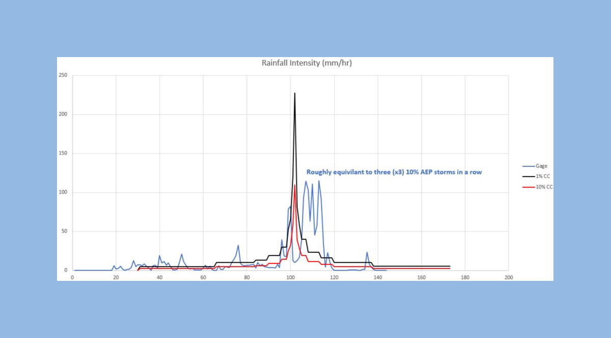
Moving on to a technical narration of stormwater systems and the wider flood management, these are designed to a specific standard, in the case of stormwater in Auckland we use design storms which represent the probability of the storm event occurring which is then factored up for climate change eg. We are designing for the estimated rainfall events occurring in 2090 with a 2.1 degree temperature increase. For the pipes in the ground, the public or council owned pipes, they are designed to a 10% AEP design storm (a storm that statistically has a 10% chance of being exceeded in any given year) commonly referred to as a 10 year storm. This matches the pipes installed around your house under the New Zealand Building Act; importantly when we consider flooding the design storm increases to a 1% AEP or 1 in 100 design storm, so lower probability, lower frequency, but a larger volume and intensity. Once a rain fall event exceeds the 10% storm it is expected that water will surface flow; this surface flow can change from a sheet flow into a concentrated flow as land and buildings concentrate and shape the water into something that resembles a stream, this is called overland flow. When streams rise, and the additional flow means the stream exceeds its stream banks this is a floodplain. Overland flow and floodplains are generally the two main terms used for flood hazards.
Properties affected by flooding would typically be assessed against the 1% event and the resulting overland flow path or the flood plain that results, essentially this is the benchmark for flood risk.
To provide a summation, 10% flows go to pipes and flow in excess of the 10% go to overland flow or floodplains, and then the level we model the flood hazard to is equal to the 1% design storm, this is the worst case considered for typical residential development.
So how big was the storm Auckland experienced? Using the Albert Park rain gauge data to understand the recent event, the volumes and comparisons are as follows;
- Historical 10% – 115mm/24 hours – climate change adjusted 135mm/24 hour (water to pipes)
- Historical 1% – 176mm/24 hours – climate change adjusted 208mm/24 hour (worst case modelled to ground)
The measured 24 hour rainfall on Friday 27 Jan was 281mm, 60% over what we would currently expect and 35% over the future climate change adjusted design storm.
If you have read this far you must have some interest so to get a little deeper, a design storm has a shape, called a rainfall hyetograph, in a nutshell the storm builds over a period; peaks and then drops away. The Auckland event exceeded the 24 hour total depth but it did not see the intensity associated with the Auckland 1% design storm, however it did have 3 peaks over a period equal to the 10% storm. The result of this is effectively an increase in total volume beyond the 1% storm. There is another layer of complexity below this with how rainfall translates to flow and times of concentration but to keep this high level we are only talking about rainfall.
The event experienced is beyond what we design systems to deal with, so when I say we did pretty well it is a considered view of the rain fall data to hand, a knowledge of the 1% flood modelling across Auckland and the reading and visual data available following the event. My current understanding is we experienced a larger storm event than we plan for and potentially experienced less flooding than we estimated. Essentially, I would have expected it to be worse.
So is the council to blame (common view/question)?In my view, no; everything cannot be designed to do everything – cost, risk and probability are key things that are constantly considered. Where flooding occurred; is generally where we were expecting the flooding to occur. If both private and public drains were better maintained, then potentially some of the minor flooding experienced or the duration might have been reduced however where you are located in a large catchment floodplain, the pipes are full, and the water is trapped so you are a passenger in a larger scale process at that point.
The newer development areas of Auckland which have been developed from greenfield performed exceptionally well, so that should give us confidence that the council, consultants, and the building sector are actually getting it right. Brownfield developments where houses are constructed in floodplains or overland flow paths also seem to have performed well with the elevated floor levels protecting the people and property as intended. I am sure there will be exceptions but the majority I expect went as planned, and to date the feedback from clients has all been positive that we got that one right.
I expect people will call for changes, I hope changes are considered against where we have had issues resulting from the current legislative framework and guideline documents, not an overreaction for the issues inherited over the development history of Auckland.
If you have a concern about flooding and you need help to understand the future risk then pick up the phone, send a text or an email and we’ll assist.
Kind Regards
Steven Rankin
Director
BE (Env) CPEng (NZ & Fiji) CMEngNZ IntPE(NZ) MFIE(Fiji)
If you have any concerns about flooding and need help understanding the future risk, then fill out the form below and we will contact you. If you would like to book an appointment, please mention this in the contact form below.